Teiki Mathieu Baillan surfing a self-made Alaya surfboard in Macaroni, Mentawaï, Indonesia. Photo by C. Naslain, 2009.
Aprecie e contribua!
| Achar os melhores spots |
|
|
 Canada
América do Norte
Geographic coordinates:60 00 N, 95 00 W
Coastline:202,080 km
Climate:varies from temperate in south to subarctic and arctic in north
Terrain: mostly plains with mountains in west and lowlands in southeast
Natural hazards: continuous permafrost in north is a serious obstacle to development; cyclonic storms form east of the Rocky Mountains, a result of the mixing of air masses from the Arctic, Pacific, and North American interior, and produce most of the country's rain and snow east of the mountains
Currency:Canadian dollar (CAD)
Currency code:CAD
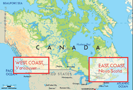
Localização: Northern North America, bordering the North Atlantic Ocean on the east, North Pacific Ocean on the west, and the Arctic Ocean on the north, north of the conterminous US
Coordenadas geográficas: 60° 0' N, 95° 0' W
Costa: 202,080 km km
Clima: varies from temperate in south to subarctic and arctic in north
Relevo: mostly plains with mountains in west and lowlands in southeast
Cimeiras: lowest point: Atlantic Ocean 0 m
highest point: Mount Logan 5,959 m
Riscos naturais: continuous permafrost in north is a serious obstacle to development; cyclonic storms form east of the Rocky Mountains, a result of the mixing of air masses from the Arctic, Pacific, and North American interior, and produce most of the country's rain and snow east of the mountains
Moeda: Canadian dollar (CAD)
População: 33,098,932 (July 2006 est.)
Línguas: English (official) 59.3%, French (official) 23.2%, other 17.5%
Capital: Ottawa
Divisão administrativa: 10 provinces and 3 territories*; Alberta, British Columbia, Manitoba, New Brunswick, Newfoundland and Labrador, Northwest Territories*, Nova Scotia, Nunavut*, Ontario, Prince Edward Island, Quebec, Saskatchewan, Yukon Territory*
Mais informações
| Jan/Feb | Mar/Apr | May/Jun | Jul/Aug | Sep/Oct | Nov/Dec | |
|---|---|---|---|---|---|---|
| Best Surfing Season | ||||||
| Typical Swell Size | ||||||
| Surf Equipment | ||||||
| Water temp. | ||||||
| Air temp. | ||||||
| Climate | ||||||
Variações sazonais de ondas e ventos
Você quer acrescentar outras informações sobre Canada? Diga-nos...
Este mapa é interactivo! Use os controles para fazer zoom ou para se deslocar.
- secções (4)
- viagens (1)
- Fotos (204)
- Vídeos (3)
- Compartilhe
- Favoritos
-
Os seus spots favoritos e as futuras listas de spots
A sua zona preferida não está na lista? Acrescentar uma zona
zonas
| zonas (3) | Spots de surf | Sub-zonas |
|---|---|---|
| Great Lakes | 17 | 0 |
| West Coast | 30 | 0 |
| East Coast | 39 | 0 |
Spots de surf
| Spots de surf (2) | Qualidade | Direcção | Tipo | Frequ | Experiência | ||
|---|---|---|---|---|---|---|---|
| Bates Island, Ottawa River | 3 / 1 | Esquerda | Desembocadura | 
|
Surfistas com experiência | ||
| Chambly Rapids | 1 / - | Direita e esquerda | Desembocadura | 
|
Surfistas com experiência |
 Fotos
Fotos
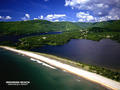
Cow bay - moose rocks |
Cow bay - moose rocks |
Ingonish beach |
Ingonish beach |
Comentários
De NthWpgBasin , 27-01-2012
There Can Be waves up to about 9 feet on lake winnipeg. - The only great surfing spot is only accessable by jetski so only about a dozen people know about it. Its in the north basin where it goes from 20 foot water to about 5 foot water because of an underwater cliff.
De Dan , 13-07-2008
Up North? - Had a mate from Yellowknife that swears the lake fetch barrels in... anybody ever been?
De Neuf , 13-07-2007
No surf in Winnipeg - There is no surf in Winnipeg - trust me I live here! Great City and beaches but no waves.
Erros, Reacções
Se você quer adicionar novas informações ou se você encontrou erros nesta página, Envie as suas observações