Teiki Mathieu Baillan surfing a self-made Alaya surfboard in Macaroni, Mentawaï, Indonesia. Photo by C. Naslain, 2009.
Aprecie e contribua!
| Achar os melhores spots |
|
|
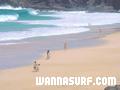
![]() El Risco
El Risco
Canary, Lanzarote
Este mapa é interactivo! Use os controles para fazer zoom ou para se deslocar.
|
Datum: WGS84 [ Auxílio ] |
Latitude: 29° 12.466' N |
Notação (11)
- Adicionar aos meus spots de surf
- Comentários (11)
- secções (0)
- viagens (0)
- Fotos (1)
- Vídeos (0)
- Compartilhe
- Favoritos
-
Os seus spots favoritos e as futuras listas de spots
Acesso
|
English (Traduzir este texto em Português): This is one of the wildest beaches on the island due to its difficult access - by boat from Orzola or by coming down the cliffs at Famara. DistânciaTome um carro CaminhadaLonga caminhada (>30 mn) Fácil de encontrar?OK Acesso público? Acesso especial4x4 |
Características do spot de surf
Qualidade do spot
Qualidade das ondasNormal
ExperiênciaTodos os surfistas
FrequênciaFunciona com frequência
Onda
TipoBeach-break
DirecçãoDireita e esquerda
FundoArenoso
PotênciaDivertida
Comprimento normalNormal (50 a 150m)
Comprimento máximoLongo (150 a 300 m)
Marés, Ondas e vento
Direcção da ressaca
Direcção do vento
Tamanho da ressacaComeça em e vai até
Condição da maré
Movimento da maré
Mais detalhes
Cheio durante a semanaNinguém
Cheio no fim de semanaNinguém
Perigos
Informações suplementares
English (Traduzir este texto em Português): park the car 2 km down the hill from mirador del rio close to the village. take enough water for the whole day there is nothing....
Ambiente
Geral
Autor: frank herrmann Contribuintes (2)
 Comentários
De anonymous , 06-11-2005
el risco is real - it is not antoher mythos of el risco...the spot exists and sometimes is works very wellall dumbs schouldt check it from mirador del rio!!!and the locals from famara are more handsome than any other local or like my mother..
De Un godo de mierda.... , 03-07-2005
- Lo que sois es unos hijos del a granputa cagones, cada vez que se pone de más de metroymedio tengo que buscar un compinche para no entrar solo.Vete a tomar por culo PELIGROSO...(hay que joderse) Seguro q te encanta el "regeton"y los coches tunin eh? payaso
Erros, Reacções
Você pode editar esta página para corrigir os erros e acrescentar novas informações. Se você tem outros comentários sobre esta página, Envie as suas observações
De Jelle , 31-03-2008
location - Hi, I'm trying to find out where all surfspots are at lanzarote with google earth/maps, but I can't really figure out this spot. I think it is over here (http://maps.google.nl/maps?f=q&hl=nl&geocode=&q=Tenerife,+Spain&ie=UTF8&ll=29.195665,-13.507433&spn=0.029633,0.067635&t=h&z=15), but is this correct? And exactly which part of the coastline that I pointed out, as that part of the coast visible in the link I posted is approx. 3 km long.